Tập tin:Positions of ancient continents, 550 million years ago.jpg
Kích thước của hình xem trước: 600×600 điểm ảnh. Các độ phân giải khác: 240×240 điểm ảnh | 480×480 điểm ảnh | 820×820 điểm ảnh.
Tập tin gốc (820×820 điểm ảnh, kích thước tập tin: 426 kB, kiểu MIME: image/jpeg)

|
Hình ảnh thuộc thể loại "geology" cần được vẽ lại bằng đồ họa vector theo định dạng tập tin SVG. Để biết ưu điểm của định dạng này, hãy đọc Commons:Media for cleanup. Nếu tập tin này đã có SVG, xin hãy tải lên đây rồi thay bản mẫu này bằng {{vector version available|tên hình mới.svg}}.
|


|
This map has been uploaded by Electionworld from en.wikipedia.org to enable the |
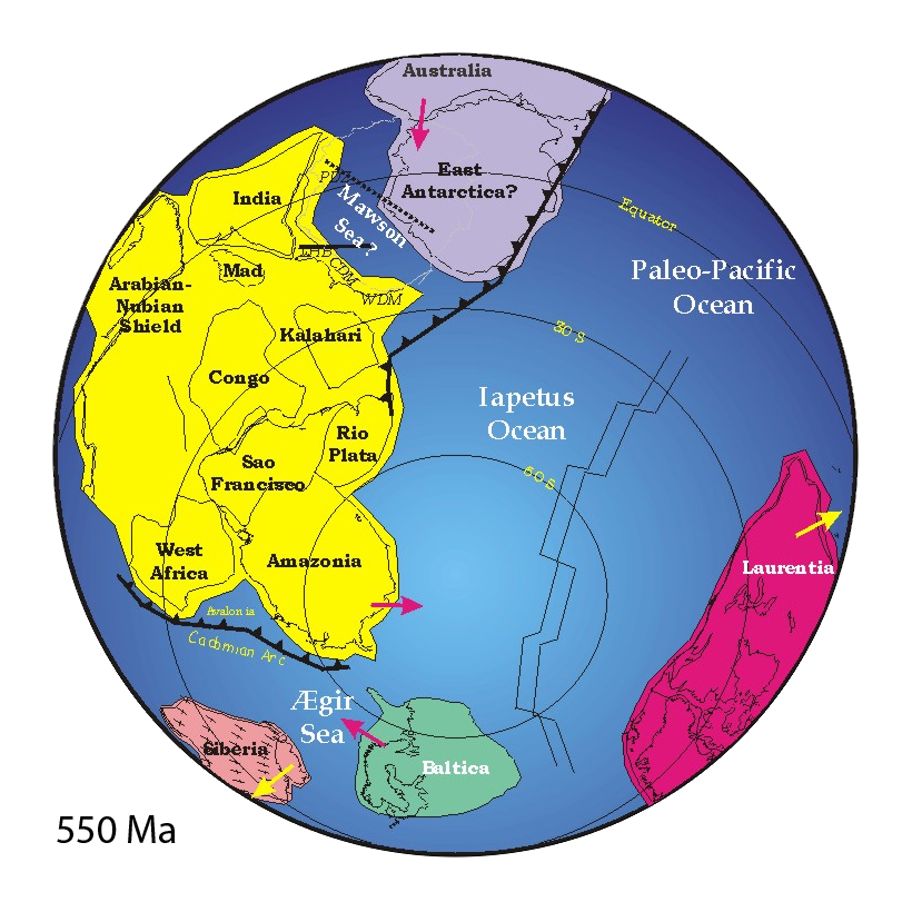
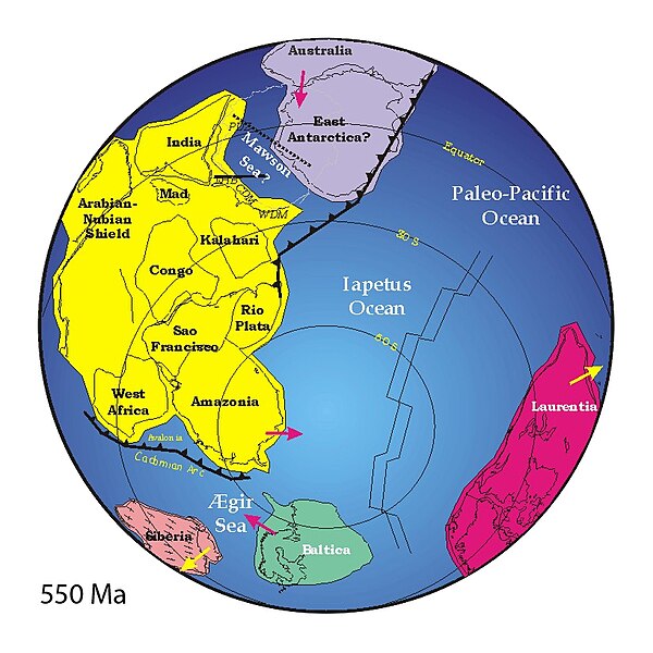
("Mad" = "Madagascar")
Miêu tả
http://www.clas.ufl.edu/users/jmeert/550.jpg
Giấy phép
| Tôi, người giữ bản quyền của tác phẩm này, chuyển tác phẩm này vào phạm vi công cộng. Điều này có giá trị trên toàn thế giới. Tại một quốc gia mà luật pháp không cho phép điều này, thì: Tôi cho phép tất cả mọi người được quyền sử dụng tác phẩm này với bất cứ mục đích nào, không kèm theo bất kỳ điều kiện nào, trừ phi luật pháp yêu cầu những điều kiện đó. |
Lịch sử tập tin
Nhấn vào một ngày/giờ để xem nội dung tập tin tại thời điểm đó.
| Ngày/Giờ | Hình nhỏ | Kích cỡ | Thành viên | Miêu tả | |
|---|---|---|---|---|---|
| hiện | 22:44, ngày 25 tháng 5 năm 2007 | | 820×820 (426 kB) | Wiggum |
Các trang sử dụng tập tin
Tập tin sau là bản sao của tập tin này (chi tiết):
- Tập tin:Positions of ancient continents, 550 million years ago.jpg tại Wikimedia Commons
Trang sau sử dụng tập tin này: